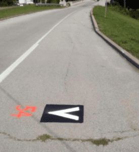
 I have had a few people ask me about these new markings in town. What are they for and what do they mean?
The markers were placed by Heartland Surveying & Mapping Co. of Muskogee, a contractor for the Oklahoma Department of Transportation.
The markers can be found on U.S. Highway 60 2.1 miles east from State Highway 123, which is scheduled for a pavement rehabilitation project on ODOT’s 8-Year Plan.
The 2-foot black square with the white chevron (or V) is used for LIDAR imaging, which, according to Wikipedia, is “a surveying method that measures distance to a target by illuminating that target with a pulsed laser light, and measuring the reflected pulses with a sensor. Differences in laser return times and wavelengths can then be used to make digital 3D-representations of the target.”
LIDAR is an acronym of “Light Detection and Ranging” or “Light, Imaging, Detection and Ranging,” depending on what source you use and, according to Wikipedia, was originally a portmanteau of “light” and “radar.”
Is Pathfinder by the old Atwoods building open yet?
The Pathfinder trail under Turkey Creek Bridge, just south of the Eastland Shopping Center, is still closed due to work underway in the area on the Oklahoma Department of Transportation bridge rehabilitation project.
ODOT contract crews are finishing the project, which had lanes on U.S. Highway 75 from Adams Road to Eastland Parkway closed for several months.
City of Bartlesville Parks Superintendent Bobby Robinson says it is unknown when that portion of the path will re-open. Keep an eye on City Beat, www.cityofbartlesville.org and the City’s Facebook page City of Bartlesville GOV for updates. (Please “Like” us while you’re there.)
Can I pay my water bill online?
Yes, you can. See Online Bill Payment on the City’s website to get started. If you still have questions, contact the Utility Billing Department at 918-338-4224. Leave a message and someone will get back with you as soon as possible.